Geography
'Bringing Geography to life for our young geographers of today!'
Purpose and Aims (Intent)
At NET, our Geography curriculums aims to ensure that all pupils:
- Develop contextual knowledge about the location of globally significant places.
- Use their growing locational knowledge, to develop an understanding of how human and physical features interact to form and shape landscapes and environments.
- Will name and locate counties and cities in the United Kingdom and discuss how the country has changed over time.
- Use maps to locate and name the world's countries. Focusing on the Europe and the Americas, they will be able to describe key human and physical characteristics. Name and locate the continents and oceans and identify the position of latitude, longitude the hemispheres, the Arctic and Antarctic and time zones.
- Can interpret a wide range of geographical information (e.g. atlases, maps, graphs, diagrams, photographs, globes, aerial photographs etc.) as well as collecting, analysing and presenting their own information.
- Experience Geography in the wider world through fieldtrips, allowing them to apply their knowledge of processes into context.
- Use correct subject-related vocabulary in both human and physical geographical focus areas.
- Understand the importance of GIS in the evolving world and be able to use it effectively.
- Gain an understanding of how world landscapes and environments change over time, including the interdependence between physical and human geography and how this causes spatial variation.
- Communicate learning in a variety of ways including sketch maps with a key and diagrams, tables, graphs and writing.
Organisation of the Curriculum (Implementation)
The geography curriculum at Jerounds has been designed to impart essential knowledge, which is planned progressively, through the NET curriculum, across key stage one and two. This planned knowledge includes vocabulary and concepts. The concepts build upon one another year after year and refer to one another over time.
All aspects of the geography curriculum are covered throughout a pupils’ time in their key stage. We ensure that learning is meaningful, ambitious, and has progression through each year and across each year group. Each academic year we start locally, in a familiar context (in upper key stage 2 this includes Europe) and move outwards into the wider world. The aim of our geography curriculum is to equip children with skills and knowledge that they can take further into their school career as well as their life after education.
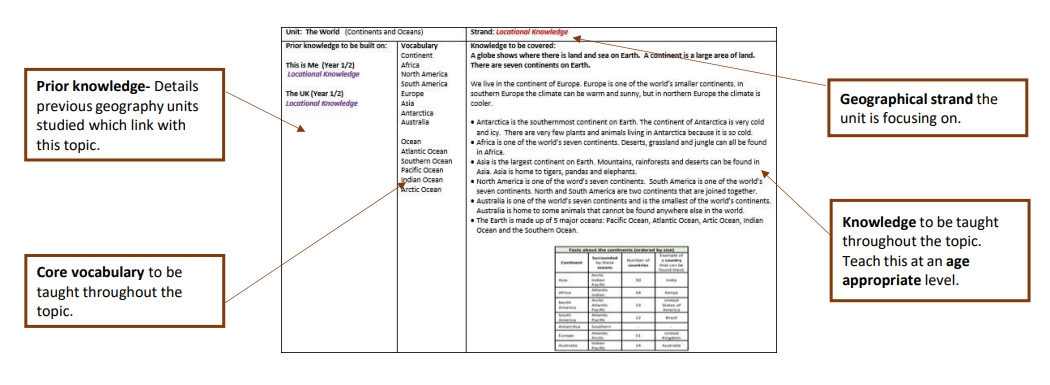
Each geography unit has a unit overview document which details the topic name, geographical strand, key skills, prior knowledge, core vocabulary and knowledge to be embedded.
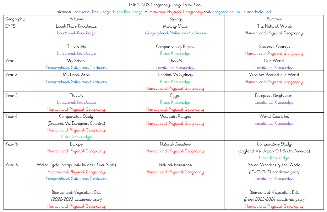
Geography is spilt into four repeating strands that continue throughout the whole curriculum. These are as follows: locational knowledge, geographical skills and fieldwork, human & physical geography and place knowledge.

As a geographer, pupils will have the opportunity to develop skills in the following domains:
- Geographical enquiry
- Direction/location (compass points, following directions, grid references)
- Using and drawing maps (including GIS)
- Map knowledge representation (symbols/use of a key), different styles of maps (including GIS)

Planning and Assessment (Impact)
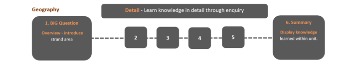
Pupils follow a sequence of learning, starting with an idea or question and learn new knowledge in detail through enquiry, culminating in a demonstration of knowledge learnt within the unit. Unit Overviews (see above) and Knowledge Organisers (examples at bottom of page) have been created to assist with planning and lesson sequences. A wide range of physical and virtual resources are used to support with the pupils' learning, including maps, atlases and GIS software such as Google Earth and ESRI.
A wide range of assessment strategies are used to help assess students' knowledge and skills:
- Pupils regularly retrieve knowledge from memory to help them remember and organise their knowledge. This is coupled with feedback. Teachers think carefully about what pupils are being asked to retrieve and whether this prioritises the most important content.
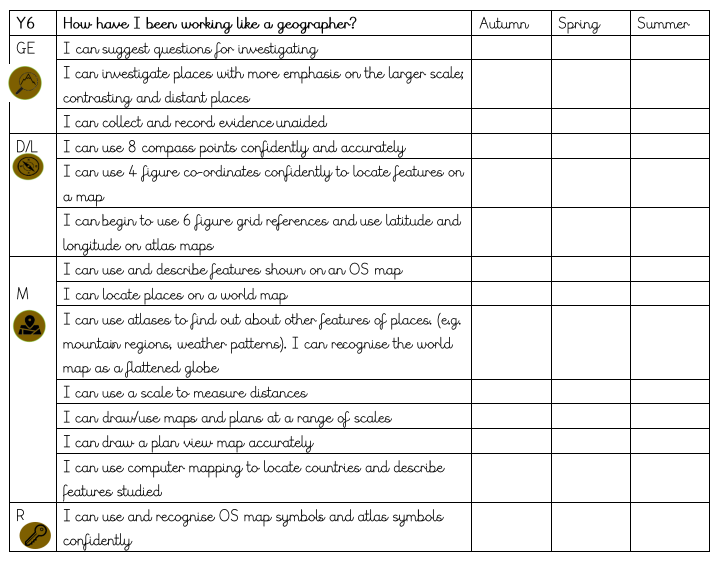
- Systems are in place to support teachers to make accurate decisions when assessing pupils’ work. This includes supporting teachers with the range of skills for children to work towards in each year group.
- At the end of each unit, quizzes and/or graphic organisers are used for children to demonstrate the knowledge learnt within the unit.
- KWL activities (such as use of the Park-It board) are used regularly, giving pupils the opportunity to share prior knowledge and what they would like to discover during the course of a unit/lesson.
- Recap and Recall at the beginning of each lesson, to recall knowledge learnt in previous lessons, units and year groups.
- Mini Plenaries during lessons to assess knowledge gained.
- ‘Plenary’ at the end of each lesson to challenge children to question beyond their learning and discuss what they could be learning next – how could they extend their knowledge further?
- Book monitoring/Pupil Book Studies.
Enrichment
By enriching the curriculum, we hope to provide extended learning opportunities for our pupils. Giving the pupil the chance to study concepts with greater depth, breadth and complexity, while also helping children to pursue their own areas of interest and strength.
Enrichment happens in the following ways:
- Use of maps/compasses/atlases and GIS software to enhance their knowledge of their local area and the wider world.
- Outdoor Learning/Survival after-school club.
- Local Study: In both key stages there is a local area study which will allow the children in KS1 to explore their local school site and surrounding area. In KS2 the pupils will look at a local river (Todd Brook) and follow its journey, including the physical and human geography along the way.
- Cross Curricular Links: Within PE pupils are encouraged to compete in orienteering and map work activities, using compasses and grid references. In Art and Music pupils learn about cultures from across the world.
- Around the World Week: During the summer term, each class studies 1 country and spends time learning about the history, geography and culture of that location.
- Home Learning: Pupils can explore geography topics and units through their homework grids which provide opportunities for pupils to embed and enhance knowledge learnt in school.